 Nome, Alaska sits on the edge of the frozen Bering Sea
Four of us spent 6 days traversing the last 200 miles or so of the Iditarod trail along the wind scoured Bering Sea coast between the village of Koyuk and the bustling bush town of Nome. This was an unbelievably diverse trip which was jam packed with broad expanses of wilderness, cultural interactions as we passed through native villages, and the excitement of the Iditarod sled dog race as we skied in the midst of the mushers making their final push into Nome. We flew out to Koyuk and then skied westward along the Iditarod trail toward Nome. Here is a map of our route between the villages of Koyuk and White Mountain.
 Here is a second map showing the last half of our trip between White Mountain and Nome. We skied right along the coast for much of the trip. This stretch is notorious for strong winds and ground blizzards - fortunately we scooted through with good weather.
 Nome is essentially a crossroad to nowhere. Everything is thousands of miles away except for Siberia and the arctic circle.
 The Nome national forest can be seen in the distance. These are actually old christmas trees that are jammed into the sea ice. Nome is beyond the treeline and is surrounded by endless tundra.
 Nome is a town of drifts because most of the snow in this windy location falls horizontally. There are several roads leading out of town but they all eventually dead end and never connect with the rest of North America.
 Bering Sea art spruces up a building in Nome.
 Arriving in Koyuk - we were met by a flurry of snowmachines that came to pick of mail and groceries. We hitched a ride down to the village store to buy a few things before hitting the trail.
 All geared up and ready begin our ski tour 200 miles back to Nome.
 Andy and Matt on the sea ice as Koyuk slowly fades away in the distance.
 There were some dramatic rock outcrops along the shore.
 Descending into the Kwik (pronounced "gweek") River valley.
 Kwik River cabin - our first in a series of luxury accommodations. No reservations are needed because this is a shelter cabin.
 The cabin was stocked with plenty of firewood by the Elim fire department. We donated some cash when we arrived in Elim the following day.
 Fighting our way through a ground blizzard. The Kwik River cabin is located in what is called a "blow hole" where strong winds can materialize in a very short amount of time. Well...the wind picked up overnight and increased after we hit the trail.
 The winds subsided some as we approached the summer fish camps at Moses Point.
 Lisa skis on towards Elim...
 Matt and Andy taking a break outside of Elim.
 The village of Elim is in a beautiful location where the "interior meets the sea"
 The primary method of transportation in rural Alaska is either snowmachine or 4-wheeler. In Elim we stayed at the school which is in the distance.
 Matt stocks up on frozen pizzas for dinner. We didn't have to carry much food because we could purchase supplies at the village store.
 We had the master key to the Elim school so we were able to cook dinner in the home ec room and use the locker room to take showers.
 Art on display at the school.
 Driftwood and dry sea grasses protrude through the snow along Golovin Bay.
 Skiing across the sea ice on the way into Golovin.
 The village displayed colorful signs to welcome the Iditarod mushers.
 A boat in Golovin waits for the ice and snow to melt.
 We arrived in Golovin just as the kids were finishing up ski practice...
 Eating breakfast in the school cafeteria with the Golovin kids.
 Golovin through stained glass.
 Our fourth night was spent in White Mountain. The Iditarod mushers caught up to us while we were here and we skied along with them on the trail into Nome.
 Dog food and other supplies for the Iditarod mushers line the banks of the Fish River.
 Iditarod champion Lance Mackey feeds his team during his mandatory 8 hr layover in White Mountain. Mushers are not allowed to have any outside help getting water or feeding their dogs. So much of the 8 hrs is spent tending to the dogs.
 Resting in White Mountain.
 Lance Mackey leaves White Mountain and makes his final push to Nome to win the 2008 Iditarod.
 There were over ten teams in White Mountain at one time.
 A musher moves along the coast...
 We spent our final night on the trail at the Topkok trail shelter.
 Inside the Topkok shelter...
 Many teams passed by at all evening and through the night.
 Pete caught up with us just as we were leaving the Topkok shelter. He was in the final 50 miles of his 1100 mile bike ride on the Iditarod Trail. He was competing in the Iditarod Trail Invitational and was the first person to reach Nome. Much of the trail was soft and competitors had to push there bikes through soft snow for many days.
 The Safety Roadhouse is the last checkpoint before Nome.
 Almost to Nome...
 Iditarod finish line on front street in Nome and the end of our ski trip.
Sunday, March 16, 2008
Skiing the Iditarod Trail

Thursday, March 6, 2008
Nome-ward Bound...
 I am headed out to the Seward Peninsula in western Alaska tomorrow with my skis and some friends. The Seward Peninsula is a thumb of the state that points directly at Siberia. All that separates Alaska from far east Russia is the icy Bering Strait.
 We will be flying into the the town of Nome on the frozen Bering Sea coast and then continuing on to the native village of Koyuk. The plan is to ski the last 200 miles or so of the Iditarod sled dog race trail back to Nome. This stretch of trail is notorious for severe winds and white out conditions. There are very few trees and most of the terrain is exposed tundra. I am hoping the weather is somewhat subdued and we are spared any strong headwinds or blizzard conditions. The Iditarod is currently in progress and we expect the lead mushers to pass us on the trail as they make their final push into Nome.
I spent the evening packing a bunch of food and snacks for 5 or 6 days on the trail. We will be passing through several native villages so we will have the opportunity to buy food along the way - for an outrageous price of course. This should be an awesome trip through some interesting country. I will post some pics when I return...
Sunday, March 2, 2008
Kite skiing
 Dan cruises down the frozen Tanana River in Fairbanks
Industrious young Dan decided he wanted to build a kite for skiing. So he found a design online, ordered the materials, bought a sewing machine, taught himself how to use the darn thing - and voila! he made a kite! Since there was a little bit of wind today - Dan, Ted and I headed down to the Tanana River to get some practice flying the kite. After a few attempts I began to get the feel for how to control the big green wing. We were able to zig-zag down the river using a method similar to tacking a sailboat into the wind.
 From the field test today it appears that a steady breeze around 10 mph is sufficient for this size kite. If the wind gets much stronger it is difficult to control...anything less will get the kite airborne but there will not be enough force to pull you forward. Dan plans on making several different sized kites so he can go out in a variety of wind conditions.
 Dan concentrates as he maneuvers the kite down the river. We spent a lot of time trying to spin it around to get it untangled.
 Well...kite skiing isn't as easy as it appears.
Check out this video of the kite in action
Wednesday, February 27, 2008
Water waiting to be released
 Ben measures the weight of a snow core near the Alaska-Yukon Territory border
I traveled up the Taylor Hwy in eastern Alaska the past couple of days to help the Bureau of Land Management (BLM) with monthly snow surveys. Snow surveys are performed around Alaska (and the rest of the US) by various agencies during the spring in order to determine the amount of water locked up in the winter snowpack.
In a few months above freezing temperatures will arrive and all of this water in storage will start to melt...and begin its long journey down into the river systems and eventually to the sea. Knowledge of the amount of water stored in the snowpack is important for river and flood forecasting because this will help determine the likelihood and/or severity of spring flooding. In the western US, this type of snowpack information is especially important for water supply planning and determining potential drought conditions.
 The Taylor Hwy is closed in the winter so we traveled nearly 200 miles on snowmachines to reach all of the snow survey sites. The Taylor is not really a highway in the general sense...much of it is a narrow dirt road with hairpin turns that connects the Alaska Highway with Eagle, Alaska and Dawson City, Yukon Terr. The road was in great shape because it was being groomed for the International Poker Run - a snowmachine trek between Tok and Dawson City. The road was essentially a 100+ mile ski track...do I see a future ski trip?
 So we measured snow depth and snow water equivalent (or the amount of water in the snow if it were melted) at 5 points in a line at what is called a "snow course." All of the snow courses we sampled were established back in the 1960's. This is a relatively long climatological record of the snowpack for Alaska. Snow courses are scattered all around the US. The snow water equivalent can also be measured remotely from aircraft and satellite. I went on a flight last spring that took measurements using airborne gamma radiation (see this post).
 The scenery is beautiful along the Taylor Hwy. This is a birds eye view of the Walker Fork of the Fortymile River.
 We passed through Chicken on our trip - too bad I wasn't here 3 weeks ago when the temperature bottomed out at -72F (-57.8C) for a few days. It was a balmy +5F (-15C) today.
 We spent the night at the "not so" rustic Chicken Field station owned by the BLM.
 The "Y" - this is the junction of the Taylor and Top of the World Highways. From here you can either go north to Eagle or east to Dawson City, Yukon.
 Frosted willows near the Alaska-Canada border.
 The spring sun brightens my view from the snowmachine.
 Headed back to the office...
Sunday, February 24, 2008
Re-Doin' Kanuti Hot Springs

 Our route started at Milepost 103 Dalton Hwy at the site of a former arctic circle gift shop which sits in the shadow of the Alaska Pipeline. At one time the owner of the shop trapped in this area and back then it was possible to follow part of his snowmachine trail which went toward the springs. No packed trails this year...
 My tracked our course. There is no established trail to Kanuti so we went cross country and tried to pick a route that avoided thick brush, trees and deep snow. It was about 11.5 miles from the highway back to the hot springs.
 We had a good climb up to the south flanks of Caribou Mtn. There was a great descent after that toward the springs.


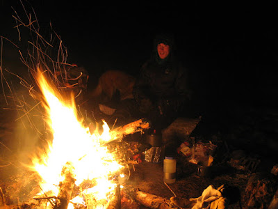 So we set up camp and got a raging fire started before we soaked. It was an awesome night relaxing in the springs as the fire crackled and cast and warm orange glow on the hot water -- and the sound of water trickled down the creek away from the springs. We got the fire going so hot that we were able to spin around in front of it like rotisserie chickens and dry off before slipping our clothes back on and crashing for the night.
 The next morning we woke up to a snow storm -- I thought to myself: "Oh no, we might lose our nicely packed trail on the way out."
 The snow was quite beautiful though as it delicately coated all the small branches and trees. It lost its beauty some when it came tumbling down onto our heads and down our backs as we broke our way through the brush.
 Sky the wonder dog saved us because there were a lot of spots where our trail vanished in the freshly fallen snow - she tracked our trail all the way back to a snow cairn Dan had built to mark our trail into the dense forest.
 Damn! We left the dome light on in the car and the battery was completely dead when we returned. After an hour or so we were able to flag down an Alyeska pipeline employee and had him jump it for us. So the lessons learned: 1) make sure all lights are off before departing and 2) always back into your parking spot so someone can reach the battery for a jump.
Sunday, February 17, 2008
Scratched - a mental battle
 We're off--100 miles into the Alaskan wilderness.
The Susitna 100 took place down near Wasilla this weekend. This is a 100-mile endurance race on backcountry trails where competitors can choose to bike, run or ski. All racers are required to carry 15 lbs of mandatory survival gear including a -20F sleeping bag, sleeping pad, bivy sack or tent, etc, etc.
The trail conditions and weather were brutal at times--strong head winds, blizzard conditions, a dump of snow, and many miles of blown over and drifted trail. This year the course was far more challenging than in 2006 when we were battered by heavy rain, wet snow and winds. In 2006 the trail was hard packed and fast despite the hypothermia inducing weather conditions. A large percentage of people scratched during this years race and many others didnt even attempt to start. For those that did finish, the overall times this year were some of the slowest ever in the races history.
 Kristen and I sort out our food the night before the race. Fritos are one of my secret endurance race snacks--and only 3 ingredients: corn, oil and salt. No preservatives. Salt...yum...
 This is actually one of the very few wider sections of trail that wasn't drifted. Much of the course required a lot of double poling and marathon skiing (pushing with one foot) because the trail was soft and narrow. The trail was much better suited for old school classic skiing rather than skate skiing. It was easy to catch my tips on the edge of the trail and tumble face first into the snow.
 Ground blizzard on Flathorn Lake - this was the view as we came out onto the lake near the first checkpt. I thought to myself : Holy crap! are people really going to continue into this? They did so I pushed forward... Conditions actually worsened in the aptly named "Dismal Swamp" where 30+ mph headwinds blew the snow around and completely obscured the visibility. This is the point where Kristen bagged it and headed back. (picture stolen from Up in Alaska blog)
So I continued on to the Eaglesong checkpoint at mile 44. About 2 miles out my pole punched several feet into the soft snow. As I fell onto the submerged pole it exploded from my weight and when I pulled it from the snow I found that I had a 3 foot carbon fiber shaft dangling from my wrist - it split in half. I was able to limp my way into Eaglesong with one pole. The folks at the checkpt found an old retro bamboo pole in a shed that was about a foot shorter than my remaining good pole.
Word on the trail was that conditions ahead were bad but after some food and rest I decided to keep going. So I headed out into the late evening darkness and within a mile or so the strap on the newly acquired bamboo pole shredded to pieces. I attempted repair it in the field but it was too far gone and I went back to Eaglesong. I fixed the strap but at this point I had to make a difficult decision: !!Scratch!! - I did it. And now I was going to have to be content with this decision. At the time it seemed more logical to return to the start line on a trail I knew rather than heading into the unknown with what seemed to be an unreliable pole. So I left Eaglesong around midnight and got back to the start around 10 AM. 82 miles and 25 hours later I found myself back where I had started feeling somewhat disappointed and conquered.

Back at the start/finish with the bamboo pole and broken carbon fiber pole.
So I am still suffering from a bit of "scratchers remorse" because I feel like I should have made one last attempt and push forward with the old bamboo pole. I was able to make it back to the starting line without any mishaps so I should have easily been able to complete the course. I suppose its easy to think this from the comfort of home--which is a totally different mindset from being out on the trail, in a snowstorm, frustrated with malfunctioning equipment, stories of horrendous trail conditions ahead, and the uncertainty that the retrofitted pole will hold up. At the time it certainly felt like the most reasonable decision and I guess that is what really matters. With a look on the positive side...I do feel like I am walking away from this race with more confidence in my ability grind on through taxing conditions, I acquired some new techniques for skiing over rough trails, I will always carry an extra pole on extended trips, and I appreciate the opportunity to be out in some beautiful country under grueling conditions.


