 Soaking in one of the pools at Kilo Hot Springs
We were about four miles from the springs when my ear captured the muted buzz of a plane as it skirted over a distant ridge. The small aircraft passed just overhead and continued west before disappearing between the building cumulus clouds. I felt a sudden pulse of excitement and relief surge through my body. And as I glanced over at Dan and Ann I could see that they shared the same sensation. We knew within a few hours we would be lounging in the hot springs, sipping the bitter sweet combination of gin and tonic, satiated from a warm meal, all in the company of our friends.
At this point, we had been moving almost constantly across the rugged terrain of the Ray Mountains for the past two days with only a few hours of sleep. The plane was our quick exit back to civilization. It would carry us effortlessly over the deep and thickly vegetated valleys, rocky scree slopes, ankle twisting tussocks, and endless stretches of mosquitoes. There were a number of reasons that could have prevented our aerial transport from reaching our prearranged rendezvous point though; foul weather, mechanical problems, illness...and these thoughts lingered silently in the back of my mind for the duration of our trip.
 Kilo Hot Springs is situated in a broad valley on the marge of a crystal clear stream that drains north from the Ray Mountains. The nearest road or community is more than 40 miles away. Access to the area is difficult since there is no airstrip or trails. A well drained tundra ridge about 5 miles from the springs serves as makeshift landing spot. We began our journey to Kilo from the Yukon River bridge along the Dalton Hwy. Paddling 20 miles down the mighty Yukon to an undefined ridge, we packed up our boats and climbed steeply into the high country of the Ray Mountains, traversing about 45 miles on foot to reach the springs.
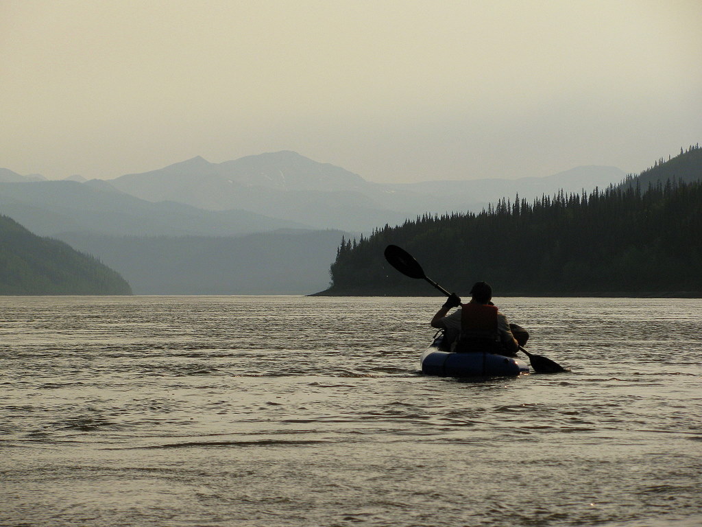 Smoke from early season wildfires settles into the Yukon River valley as we paddled 20 miles to our take-out point. The Yukon River narrows considerably below the Dalton Highway as it approaches a pinch point know as the Rampart Canyon. This narrow neck was once considered a feasible site for the hydroelectric producing Rampart Dam, which was estimated to flood an area the size of Lake Erie.
 We pulled our packrafts out of the Yukon at an unassuming ridge that would provide us with direct access the treeless high country.
  The steep ascent quickly provided us with a panoramic view of the Yukon River far below.
 Crossing sweeping carpets of tundra pockmarked with treacherous, ankle twisting tussocks en route to Kilo Hot Springs.
 The muggy heat forced us to dip for water in even the slimiest of tundra ponds.
 Furry willow catkin's and new spring leaves absorb the late evening sunlight.
 Some of the granite tors jutting from the tundra resembled giant prehistoric creatures grazing on the distant hillsides.
 Our friends flew in from the Dalton Highway, hiked five miles down from the plane, and met us for a night of soaking in Kilo Hot Springs.
 Dea and Ben sit around the campfire and listen to our stories about the exhausting trek to the springs from the highway -- a grizzly bear encounter, cracks of thunder and strong winds on the Yukon, torn up feet, falling rocks, never-ending ascents and descents, spongy tundra, expansive views, untouched wilderness...
  The springs are home to an abandoned homestead. Three cabins remain just upstream from the main hot springs. At least one of these cabins was situated adjacent to the springs but was relocated to it's present location a few years back.
 The closest place to land a small plane is on a firm ridge about five miles from the springs. It was a 30 minute flight back to the highway.
Above is a video account from the trip to Kilo Hot Springs.
Sunday, May 30, 2010
Rendezvous at Kilo Hot Springs

Sunday, May 16, 2010
Day Trippin' the Middle Fork Chena River
 Eager packrafters head towards the Middle Fork Chena River.
A winters worth of ice has flushed out of local rivers, the snow has melted, and the packrafts have reappeared after 8 months in hibernation. We headed to the hills east of Fairbanks for the first packraft excursion of the season. This was a pleasant day-trip right in our backyard playground known as the Chena River State Recreation Area. 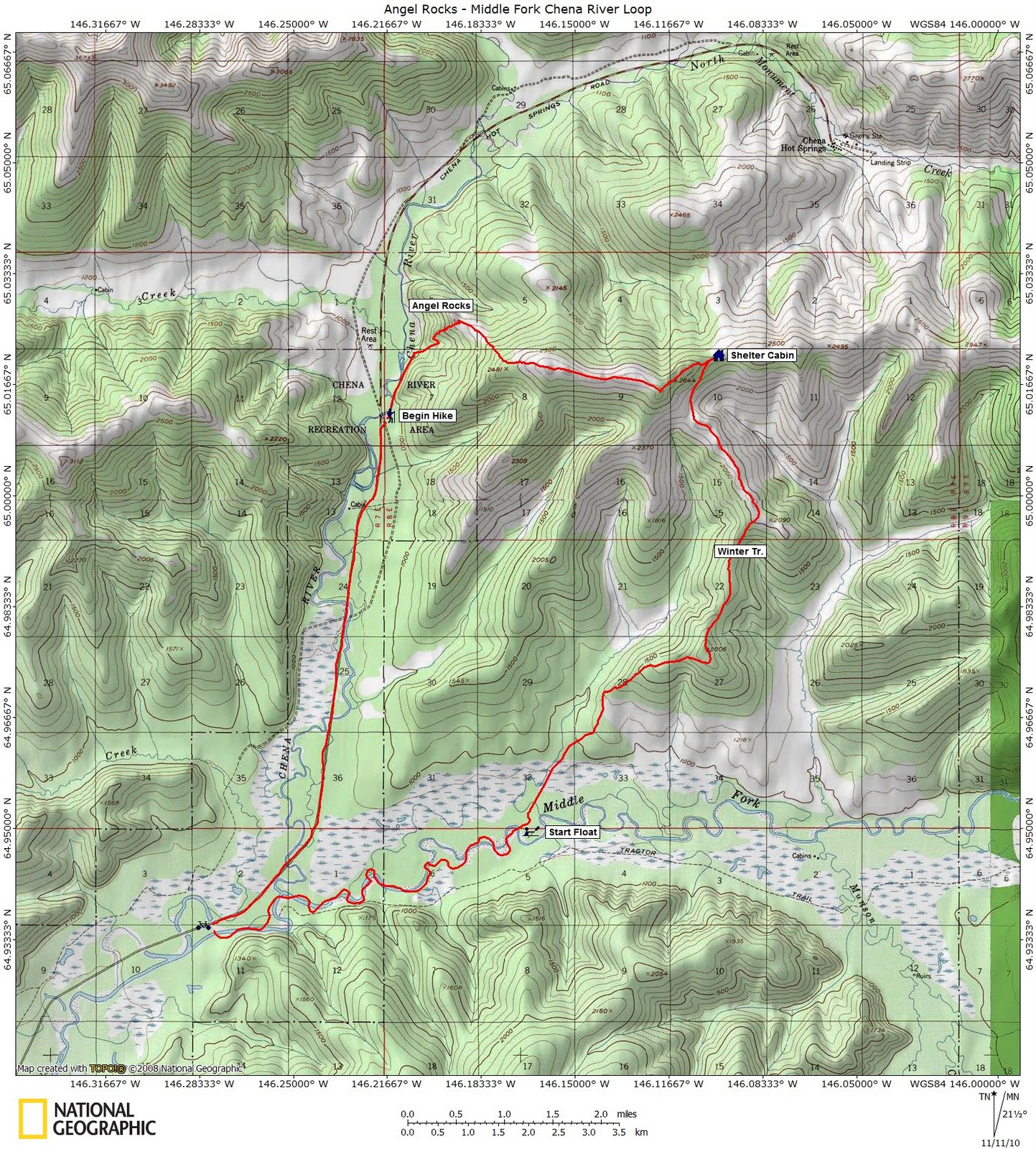 Our hike began at the Angel Rocks trailhead. After a steady climb to the granite outcroppings that mysteriously protrude from the boreal forest, we continued the steep ascent to a tundra ridgeline on a connector trail that eventually leads to Chena Hot Springs. Just before reaching a small shelter cabin, a winter trail spurs off to the south and descends down to the Middle Fork Chena River. From there we floated back to the road where bikes can be stashed. Then its a quick 6-mile ride or run back to the vehicles. Total hiking was approximately 12 miles and the 6-mile float took us about 2 hrs.
 A boardwalk elevates hikers and alleviates damage to the fragile, yet burnt, vegetation below.
 The first few miles of the trail are well marked. The trail to Angel Rocks is one of the most popular in interior Alaska.
 Excellent walking and views of the Tanana-Yukon Uplands and Alaska Range.
 In a saddle at the eastern end of the ridge, sits a small trail shelter. A trail marked with cut-up road signs branches off to the south just before reaching the shelter. The relatively firm trail follows a ridge down to the Middle Fork Chena River.
 The trail splits just before reaching the boggy wetlands around the river. One trail leads into a network of small beaver dams and flooded forest.
 The put in on the Middle Fork Chena River is about 12 miles from Angel Rocks.
 The Middle Fork is a casual class I float with an occasional sweeper or log jam to avoid. The take-out is at well established gravel bar and pullout at Milepost 43 Chena Hot Springs Rd. Jay pioneered this route and has some additional information HERE.
Tuesday, September 8, 2009
Packrafting in Technicolor
 Vibrant colors illuminate the East Fork Susitna River basin
The wide spectrum of light sent me into a visual overload. It seemed like my brain was confused at how to process the incredible array of wavelengths entering my eyes. My vision had previously adjusted to the washed out colors brought on by a rather cloudy and wet, monochromatic August. But as September and autumn rolled in, summer-like weather decided to throw one last performance with bright, warm sunshine lighting up a chromatic display of fall foliage.
We headed into the Alaska Range south of Fairbanks for our final packrafting trip of the season. My nephew and I had traversed the Clearwater Mountain area earlier in the summer, and I was excited to return and explore more of this countryside. I was intrigued by the easy access to the open tundra, shimmering alpine lakes, sweeping valleys, and dramatic views of glaciated peaks looming above the horizon. All of this is within easy reach of our limited Alaska road system. We started our trek near the end of the Valdez Creek mine road, at which point a dendritic network of mining trails branch out into the surrounding mountains. These trails provide easy access to the high country. Our traverse led us up one of these paths for about 6 miles, at which point we veered off and paraded across the tundra for an additional 20 miles of cross country walking. Our destination was the East Fork Susitna River a few miles from its start at the terminus of the glacier with the same name. From there we floated 32 miles back to the Denali Highway bridge where we stashed bikes and running shoes for the 11 mile trip back up to the truck. The walking was superb with firm tundra, minimal bushwhacking, excellent alpine lake swimming, easy floating and portaging, plentiful wildlife viewing, along with classic Alaska scenery.
 We had to cross Valdez Creek a handful of times as we worked our way up the drainage. A well established 4-wheeler trail provided easy access to the alpine and eliminated the need to fight our way through the chest high dwarf birch.
 A classic example of solifluction lobes are draped along the hillside. These features resemble oozing tongues of molasses. They are created as the first meter or so of frozen soil, also known as the active layer, thaws during the summertime. Gravity takes its toll on this water saturated active layer of permafrost and it slowly slips downhill along the interface with the permanently frozen ground below.
 Curious caribou are prevalent in this part of the Alaska Range.
 The tundra grasses and sedges had transitioned into a soft yellow carpet with the onset of fall. In July my nephew and I had strolled down this valley through fields of wildflowers on our way to float Clearwater Creek. For this trip we just skimmed the upper edge of the drainage on our way to a rock strewn pass.
 The vertical face of Mt Deborah towers over Ben and Heather.
 The fall foliage reflects from one of the many unnamed alpine lakes.
 Dea and Heather enjoy the unbelievably stellar walking across the firm tundra and brush free landscape.
  Ben approaches yet another beautiful, crystal clear lake. We swam in nearly every pool of water we encountered along our route.
 Our progress was slowed by the bountiful supply of plump blueberries which weighed down the bright red bushes.
 A choir of cotton grass stands proudly along the edge of another nameless alpine lake.
 Ben hesitantly walks through the bright red-leafed blueberry bushes as he makes the final descent to the East Fork Susitna River.
 A carpet of tundra and game trails led us right down to our put-in on the silty waters of the East Fork Susitna River.
 The East Fork Susitna River was mostly easy class I water, except for a 1.5 mile stretch of rapids just above the confluence with the main stem of the Sustina River. At the water levels we encountered, the rapids were generally class II, with a very short class III rocky drop which required some quick maneuvering.
 Portaging around any portion of the rapids on the East Fork Susitna was easy due to a well worn game trail along the south bank of the river.
 A portion of the 1.5 mile stretch of rapids on the East Fork Susitna River. A very short class III bouldery section is just up river from this point.
 The glaciated peaks of the Alaska Range dominate the skyline above the main stem of the Susitna River. We dragged and powered our way through a few miles of very shallow, braided channels on the Susitna River. Otherwise, the entire traverse was an awesome way to close out the 2009 packrafting season.
Monday, July 20, 2009
Silence in the Clearwater
 Mark and Sky descend a mountain pass in the Clearwater Mountains
We finally settled down and started to cook dinner around 1 am under the dim twilight. It was noticeable that the nights were gradually getting darker as time slowly slid away from summer solstice. The two of us perched ourselves on a cushion of tundra overlooking a glassy alpine lake as we devoured our warm meals from the self contained aluminum bags.
Mark was the first one to notice it. I had sensed that something was different but no conscious thought had surfaced until he pointed out the obvious. It was completely silent...dead still. There were no birds, not a single movement of air to rustle the miniature leaves on the surrounding sedges -- but this place was void of something more prominent. Bugs! There was no incessant buzzing of mosquitoes. We had been so accustomed to a constant hum in the atmosphere this summer that the lack of sound felt strangely discomforting. This was our last trip together before Mark heads back to his home high in the Rocky Mountains of Colorado and tends to more important things like high school and cross country running. Mark was eager to do a multi-sport trip which would combine hiking, boating, and cycling. We decided to explore the Clearwater Mountains: an accessible subrange in the greater Alaska Range along the Denali Highway. A very well maintained road and network of 4-wheeler trails lead to the tundra in the Valdez Creek mining area. We followed one of these paths until it spit us into the alpine. From there we hiked about 18 miles to Clearwater Creek, dropped our packrafts in the water and floated 15 miles to the Denali Highway, and then biked 35 miles back to the truck. A complete 70 mile loop which can easily be completed in a 3-day weekend.
 We scrambled up a pass above Grogg Lake en route to our put-in on Clearwater Creek.
 A dense population of caribou in this area have developed a well worn web of trails through the lower elevation brush. This made for easy walking as we dropped down into the Clearwater Creek drainage.
 We put in on Clearwater Creek at the confluence with a tributary which contributed enough water sufficient for floating.
 The creek was almost entirely Class I water with a short stretch of rocky...non butt dragging...Class II riffles with some boulders to dodge.
 The take out at Milepost 55 Denali Highway. I was skeptical about floating this river when I saw the low volume of water flowing under the bridge. The trip was surprisingly nice with plenty of water to keep the boats afloat.
 Heading west on the Denali Highway and back to the truck.
Sunday, July 12, 2009
Whitewater on Windy Creek
 Ben and Tyler take a ride down Windy Creek
Windy Creek is often used as an approach to access the Sanctuary River in Denali National Park. This clear boulder strewn ribbon of water also makes for a superb day trip. When I first walked up this drainage en route to the Sanctuary River via Windy Pass I was so focussed on my final destination that I somehow overlooked its amusement park ride-like floating potential. Fortunately a fellow packrafter pointed out the obvious in a post on the internet. A well worn 4-wheeler trail branches northwest from the community of Cantwell and crosses a low divide before narrowing down to a single track where it descends into the Windy Creek drainage. We hiked about 5 miles along this path from Cantwell to an undefined spot that looked like a great starting point. This was followed by a 9 mile float down Windy Creek and the Jack River -- eventually pulling out where the Jack spills into the Nenana River. A short portage through the brush brought us back to the road. From there its a pleasant 8-mile bike ride or run back to the vehicle in Cantwell. The ideal trip..no car shuttle required.
 Mark gazes down at the others clambering on all fours as they climb a steep bluff along Windy Creek.
 The upper part of Windy Creek is very fun and steady class II water with lots of small drops and standing waves. The volume is relatively low so there are no big hydraulics or unmanageable holes to contend with. Its a confidence boosting intro paddle for newbies to whitewater packrafting. The lower river is a mellow class I "chill out" and soak up the scenery float.
 Tyler prepares to re-enter the river after one of our numerous stops to dump water out of the boats.
Videography from Windy Creek


