Thursday, June 25, 2009

Kids on the Itkillik

Dwarf fireweed casts a midnight shadow along the Itkillik River

I looked back over my shoulder and they were still there. Completely lost in their thoughts and undoubtedly struggling to deal with the miserable situation. I began to seriously question my decision to bring two 15-year old kids on this trip. We had been stumbling across knee deep tussocks in the late afternoon heat fully draped in our armor of raingear for hours. The uneven surface made it nearly impossible to move in any direction. Each erratic and unstable step ended with a sharp roll of the ankle as we clumsily navigated through the maze of towering tufts of grass. But we had to keep progressing forward because the incessant humming of the mosquito filled atmosphere was maddening. The continuous ricochet of bugs against our bodies felt like a torrential shower of raindrops pelting our clothing. There was no choice but to move on to a place where the ground would firm up enough to allow us to setup camp and take refuge in our tent.


I knew better than to head to the Arctic this late in June but I thought we had a few more days of reprieve before the onset of bugs. We were a day too late. The season is short this far north and the tundra explodes with new life every hour during the start of the brief warm season and 24-hour sunshine. My nephew Mark and his friend Mara were up for the adventure and decided it was worth the gamble. So we spent summer solstice above the Arctic Circle in the shadow of spectacular folded limestone cliffs, fields of wildflowers, diving raptors, howling wolves, following the footprints of grizzly bears, and sacrificing ourselves to the hordes of blood thirsty mosquitoes.

Our traverse would take us over the crest of the Brooks Range to the Itkillik River valley. From there we would hop in our packrafts and drift northward before beelining our way back across the tundra to Galbraith Lake about 40 road miles north of our starting point. The entire trip consisted of roughly 50 miles of hiking and 25 miles of river travel.

Our last view of the Dalton Highway before we head into the wilderness. It would be another 5-days before we returned to this industrial artery that connects the oil fields at Prudhoe Bay to the rest of the world.

An uncountable river crossing...the classic image of almost any trip across Alaska where trails and bridges are almost non-existent.

Mark gazes into an eroded cavern in the remnant river ice. Extensive areas of aufeis are common in this region. These large sheets of ice can be several meters thick and persist well into the summer. Aufeis begins to form as the river freezes and the channel becomes constricted. The buildup of water pressure forces the river to flow out of the channel and spread across the adjacent flood plain throughout the winter. Ice sheets like this often serve as the only escape from the mosquitoes for thousands of caribou.

Crossing Oolah Pass - aka the continental divide.

Mara makes the descent into the Itkillik (or Oolah) Valley past giant walls of sedimentary rock that originated as the floor of a shallow tropical-like sea. There is evidence of this past environment in the fossilized corrals and shells that can be found littered in the piles of scree.

We tromped through a lot of grizzly bear scat but never saw the source of the bodily waste.

Vibrant arctic poppies brighten the landscape.

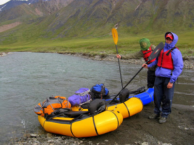
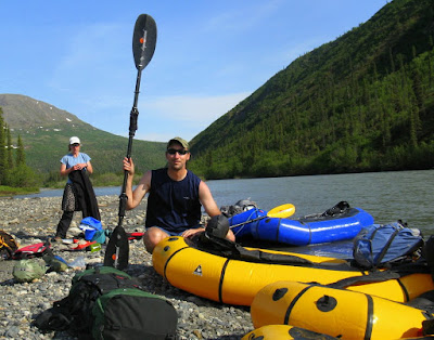
We eventually came to a point where the gradient of the Itkillik River mellowed enough for us to throw the boats in the river.

As we continued to move downriver and to a lower elevation we reached the "mosquito zone" --- our only escape was the heat from a fire fueled by dried willows.

The river was mostly class I/II water with occasional rocks and small wave trains to bounce through.

Mark paddles past a massively exposed ice wedge along a cutbank of the Itkillik River.

More frozen ground or permafrost features. A lens of ice heaves the tundra up into the warm summer air. Its hard to believe the ground is permanently frozen just below the green surface.

The uber-light and roomy tarptent sheltered us from mosquitoes, heavy rain, and moderately strong winds.

We make the final push out to Galbraith Lake and the Dalton Highway with our small insect friends in tow as another spectacular trip in the arctic comes to an end...

Monday, June 15, 2009

W. Fork Atigun Weekender

Dan rides the waves in the West Fork of the Atigun River

I suddenly felt a sense of relief as the last bit of warm blood vacated the few remaining vessels in my feet. I was no longer subjected to the excruciating pain caused by the snow and pools of slush that were penetrating my sneakers. I somehow convinced myself that no feeling is better than endless stinging. But I already knew that repeated inflictions of my feet to the cold over the years had resulted in permanent numbness to some of my toes. At this point I still didn't care. I just wanted to keep moving downhill to a lower elevation where green tundra and the first wildflowers of the summer dotted the valley bottom.

We headed north for the weekend to the Brooks Range in hopes of crossing over two passes and floating a portion of the upper Itkillik River before returning to the highway. This plan abruptly failed. A cool start to summer left large expanses of snow lingering in these mountains that define the divide between water flowing north to the Arctic Ocean from that draining southward towards the Bering Sea and north Pacific. We retreated back in our tracks after attempting to climb a sketchy ice covered pass with our inadequate gear. Instead we found ourselves bouncing down the whitewater of the West Fork of the Atigun River in a stunning Arctic valley.

Ted plunges up to his crotch as he crosses endless stretches of snow on our way over the continental divide. We delicately placed our weight on the white surface in hopes of warding off additional swims in the bottomless snow. It would be another week or so before the snow would setup and transform into a solid walking surface.

Despite the rotten snow and laborious trudging the scenery was absolutely spectacular as we descended into the upper reaches of the Atigun River.

We really were happy to be out in the mountains.

Another water crossing near the headwaters of the Atigun River flushes the cold snow out of our shoes.

We had to hike for several miles down valley to a spot where the shallow braided channels consolidated into one primary deeper channel.

Resourceful Sky chomps away on an abandonded caribou rack. She could survive a long time on small mammals and other treasures in the wild. The caribou had moved down out of the mountains to the coastal plain in preparation for calving.

The West Fork of the Atigun is pinched between the exposed bedrock. We portaged this significant drop. The remainder the river was primarily fun wave trains and navigating through partially submerged rocks.


Videography from the West Fork of the Atigun.

Preparing for the final leg: a cold rain and driving headwind forced us to vacate the boats when our waterway skirted the Alaska Pipeline and road. Mildly hypothermic we ran the last 15-miles to the truck along the muddy highway outfitted in all our clothes and life jackets with the hopes of getting a ride...no ride came.

Monday, June 8, 2009

Coffee and Pizza Traverse

Descending into the upper Nenana River drainage in the Alaska Range

All I could focus on the last two hours of our float was shoving a giant piece of greasy pizza into my mouth. The pleasurable sensation of the melted cheese against my tongue and anticipation of the calories replenishing my body. Fortunately for me our weekend traverse in the Alaska Range would terminate at the same location we started at the day before - but this time there would be unlimited pizza fresh out of the oven waiting to be devoured.

This most recent packrafting trip was aptly named the coffee-pizza traverse because it began and ended at the java shop and pizza joint which straddle the banks of Carlo Creek on the Parks Hwy. The entire loop consisted of about 15-miles of scenic alpine hiking followed by 16-miles floating the upper Nenana River.

A conveniently placed 4-wheeler path exists from the Parks Hwy up through the brush to treeline and resulted in a bushwhack-free stroll to the tundra.

Ben admires the newly melted snow as it cascades through a narrow gully.

The walking was nearly effortless across a green blanket of tundra and through fields of wildflowers.

Breaking a thin layer of ice on a small pond at our camping site near the headwaters of Carlo Creek.

Large snowfields still linger below the pass at the head of the Carlo Creek. The snow was firm enough to walk across with ease.

Ben begins the steep and rocky descent on the south side of the pass. This section required some serious scrambling over small ledges and over giant boulders. We would eventually drop into the far distant valley and plop ourselves into the cold, silty waters of the Nenana River.

Curious caribou circle around us.

The girls cross a beautiful alpine stream.

Making our way across a wide open expanse of tundra above the Nenana River.

Preparing to launch the boats. The final push down to the river was a steep descent through a brief stretch of moderately thick brush.

The Nenana River upstream of the Parks Hwy bridge is a casual Class I float. The river picks up a bit below the bridge with a few short Class II+ sections that are relatively easy to portage.

10 PM and back at the starting pt...fresh pizza...beer...live music...THE END.