 Ben measures the weight of a snow core near the Alaska-Yukon Territory border
I traveled up the Taylor Hwy in eastern Alaska the past couple of days to help the Bureau of Land Management (BLM) with monthly snow surveys. Snow surveys are performed around Alaska (and the rest of the US) by various agencies during the spring in order to determine the amount of water locked up in the winter snowpack.
In a few months above freezing temperatures will arrive and all of this water in storage will start to melt...and begin its long journey down into the river systems and eventually to the sea. Knowledge of the amount of water stored in the snowpack is important for river and flood forecasting because this will help determine the likelihood and/or severity of spring flooding. In the western US, this type of snowpack information is especially important for water supply planning and determining potential drought conditions.
 The Taylor Hwy is closed in the winter so we traveled nearly 200 miles on snowmachines to reach all of the snow survey sites. The Taylor is not really a highway in the general sense...much of it is a narrow dirt road with hairpin turns that connects the Alaska Highway with Eagle, Alaska and Dawson City, Yukon Terr. The road was in great shape because it was being groomed for the International Poker Run - a snowmachine trek between Tok and Dawson City. The road was essentially a 100+ mile ski track...do I see a future ski trip?
 So we measured snow depth and snow water equivalent (or the amount of water in the snow if it were melted) at 5 points in a line at what is called a "snow course." All of the snow courses we sampled were established back in the 1960's. This is a relatively long climatological record of the snowpack for Alaska. Snow courses are scattered all around the US. The snow water equivalent can also be measured remotely from aircraft and satellite. I went on a flight last spring that took measurements using airborne gamma radiation (see this post).
 The scenery is beautiful along the Taylor Hwy. This is a birds eye view of the Walker Fork of the Fortymile River.
 We passed through Chicken on our trip - too bad I wasn't here 3 weeks ago when the temperature bottomed out at -72F (-57.8C) for a few days. It was a balmy +5F (-15C) today.
 We spent the night at the "not so" rustic Chicken Field station owned by the BLM.
 The "Y" - this is the junction of the Taylor and Top of the World Highways. From here you can either go north to Eagle or east to Dawson City, Yukon.
 Frosted willows near the Alaska-Canada border.
 The spring sun brightens my view from the snowmachine.
 Headed back to the office...


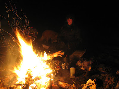 So we set up camp and got a raging fire started before we soaked. It was an awesome night relaxing in the springs as the fire crackled and cast and warm orange glow on the hot water -- and the sound of water trickled down the creek away from the springs. We got the fire going so hot that we were able to spin around in front of it like
  The next morning we woke up to a snow storm -- I thought to myself: "Oh no, we might lose our nicely packed trail on the way out."
 The snow was quite beautiful though as it delicately coated all the small branches and trees. It lost its beauty some when it came tumbling down onto our heads and down our backs as we broke our way through the brush.
 Sky the wonder dog saved us because there were a lot of spots where our trail vanished in the freshly fallen snow - she tracked our trail all the way back to a snow cairn Dan had built to mark our trail into the dense forest.
 Damn! We left the dome light on in the car and the battery was completely dead when we returned. After an hour or so we were able to flag down an
 .jpg)
 Kristen and I sort out our food the night before the race. Fritos are one of my secret endurance race snacks--and only 3 ingredients: corn, oil and salt. No preservatives. Salt...yum...
 This is actually one of the very few wider sections of trail that wasn't drifted. Much of the course required a lot of double poling and marathon skiing (pushing with one foot) because the trail was soft and narrow. The trail was much better suited for old school classic skiing rather than skate skiing. It was easy to catch my tips on the edge of the trail and tumble face first into the snow.
 Ground blizzard on Flathorn Lake - this was the view as we came out onto the lake near the first checkpt. I thought to myself : Holy crap! are people really going to continue into this? They did so I pushed forward... Conditions actually worsened in the aptly named "Dismal Swamp" where 30+ mph headwinds blew the snow around and completely obscured the visibility. This is the point where Kristen bagged it and headed back. (picture stolen from
 .jpg)
 They're off! One of the first teams heads down the 1000-mile trail to Whitehorse, Yukon.
 The
The 
 A group of us walked to the race start from Dea and Bens house through the thinning ice fog.
 We were all decked out in our warmest arctic clothing as we posed downtown on the Chena River
 Fairbanks has been swallowed by a sea of dense ice fog the past few days as the thermometer plummeted well below zero. Powerplants, vehicles and anything else that emit water vapor into the atmosphere at these temperatures create a gritty, grey layer of fog that gradually thickens until warmer air arrives. Ice fog is a different breed of fog. It develops around -40F when nearly all supercooled water vapor ceases to exist in the atmosphere...and any moisture in the air becomes entirely composed of ice. So--the fog turns the city into an opaque world where the visibility drops down to near-zero for days on end.
 Vehicles essentially create urban contrails--similar to a jet flying at 35,000 feet--that never dissipate. Driving is extremely treacherous under these conditions because the car in front of you can easily become completely obscured by the cloud of steam ejected from the exhaust pipe.
 Fairbanks is burried by a sea of ice fog--while the University situated up on a hill basks in crisp clear skies. Driving into the city is like descending into a murky cespool. During long periods of extremely frigid weather the fog is relentless and will remain over town until the cold spell breaks.
 The ice fog is mysteriously beautiful from above.


 Tim is ready hit the trail after a night at Tolovona Hot Springs.
 Check out the giant tires on Jeffs bike - these make it possible to bike through relatively soft snow.
 The guys are training for the
  Plans changed because the trail was so crummy. The guys ended up riding back to town with us. So we crammed 5 people, 2 dogs, 3 beefy bikes, skis and gear into the car.


