 Soaking in one of the pools at Kilo Hot Springs
We were about four miles from the springs when my ear captured the muted buzz of a plane as it skirted over a distant ridge. The small aircraft passed just overhead and continued west before disappearing between the building cumulus clouds. I felt a sudden pulse of excitement and relief surge through my body. And as I glanced over at Dan and Ann I could see that they shared the same sensation. We knew within a few hours we would be lounging in the hot springs, sipping the bitter sweet combination of gin and tonic, satiated from a warm meal, all in the company of our friends.
At this point, we had been moving almost constantly across the rugged terrain of the Ray Mountains for the past two days with only a few hours of sleep. The plane was our quick exit back to civilization. It would carry us effortlessly over the deep and thickly vegetated valleys, rocky scree slopes, ankle twisting tussocks, and endless stretches of mosquitoes. There were a number of reasons that could have prevented our aerial transport from reaching our prearranged rendezvous point though; foul weather, mechanical problems, illness...and these thoughts lingered silently in the back of my mind for the duration of our trip.
 Kilo Hot Springs is situated in a broad valley on the marge of a crystal clear stream that drains north from the Ray Mountains. The nearest road or community is more than 40 miles away. Access to the area is difficult since there is no airstrip or trails. A well drained tundra ridge about 5 miles from the springs serves as makeshift landing spot. We began our journey to Kilo from the Yukon River bridge along the Dalton Hwy. Paddling 20 miles down the mighty Yukon to an undefined ridge, we packed up our boats and climbed steeply into the high country of the Ray Mountains, traversing about 45 miles on foot to reach the springs.
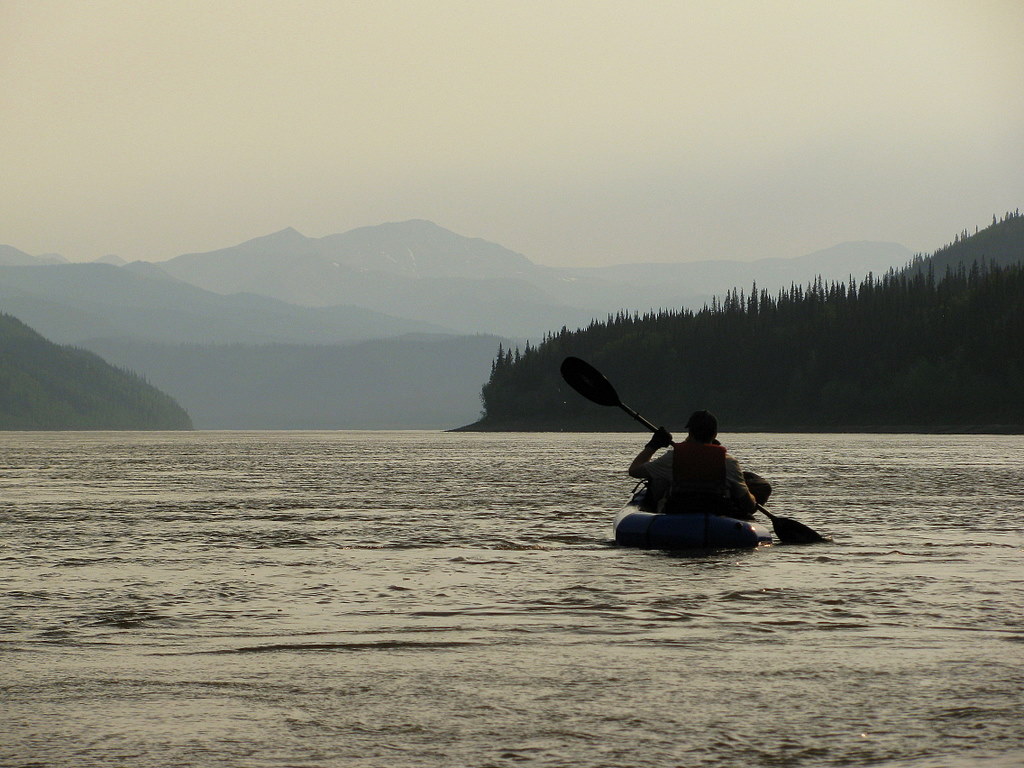 Smoke from early season wildfires settles into the Yukon River valley as we paddled 20 miles to our take-out point. The Yukon River narrows considerably below the Dalton Highway as it approaches a pinch point know as the Rampart Canyon. This narrow neck was once considered a feasible site for the hydroelectric producing Rampart Dam, which was estimated to flood an area the size of Lake Erie.
 We pulled our packrafts out of the Yukon at an unassuming ridge that would provide us with direct access the treeless high country.
  The steep ascent quickly provided us with a panoramic view of the Yukon River far below.
 Crossing sweeping carpets of tundra pockmarked with treacherous, ankle twisting tussocks en route to Kilo Hot Springs.
 The muggy heat forced us to dip for water in even the slimiest of tundra ponds.
 Furry willow catkin's and new spring leaves absorb the late evening sunlight.
 Some of the granite tors jutting from the tundra resembled giant prehistoric creatures grazing on the distant hillsides.
 Our friends flew in from the Dalton Highway, hiked five miles down from the plane, and met us for a night of soaking in Kilo Hot Springs.
 Dea and Ben sit around the campfire and listen to our stories about the exhausting trek to the springs from the highway -- a grizzly bear encounter, cracks of thunder and strong winds on the Yukon, torn up feet, falling rocks, never-ending ascents and descents, spongy tundra, expansive views, untouched wilderness...
  The springs are home to an abandoned homestead. Three cabins remain just upstream from the main hot springs. At least one of these cabins was situated adjacent to the springs but was relocated to it's present location a few years back.
 The closest place to land a small plane is on a firm ridge about five miles from the springs. It was a 30 minute flight back to the highway.
Above is a video account from the trip to Kilo Hot Springs.
Sunday, May 30, 2010
Rendezvous at Kilo Hot Springs
Monday, May 10, 2010
Dash to Dall Hot Springs
 Dan inspects one of the pools of hot water at Dall Hot Springs
I just stood there perplexed, frustrated, and on the verge of despair as I stared out at the foreboding landscape. As I spun around looking for relief, my 360 degree view was overwhelmed with jumbled, multiple layers of criss-crossed, endless slash piles of blackened spruce trees that littered the hillsides. We had been climbing around, up, through and over a twisted maze of forest destroyed by a past fire for more than 10 hours since breaking camp. The incessant minefield of jagged spears had ripped or shredded much of our clothing, gashed our flesh, and thrown us on the ground as an unseen root or branch would lash on to any loose thread. We were determined to make it to our destination though - a small flag marked on my GPS that indicated the approximate location of Dall Hot Springs. We spent the weekend traveling overland nearly 30 miles from the Dalton Highway to reach Dall Hot Springs. About 10 miles of our path crossed decent alpine tundra and open stands of burnt spruce - BUT - during much of the remaining 20 miles we clambered across the torched landscape. We only had a short time once we finally made it to the springs because we had to begin the arduous 18 hour trek back to the truck.
 A small portion of our route coincided with the Hickel Highway, which is quite a prestigious title for an abandoned winter ice road. This mostly forgotten and overgrown swath of history was cut across the boreal forest, mountains, and arctic tundra en route to explore the potential reserves of petroleum deep under Alaska's Arctic coastal plain. Governor Walter Hickel ordered the winter supply road to be bulldozed north in November 1968. The "highway" was soon ditched due the poor engineering techniques which stripped away the insulating vegetation that protected the underlying permafrost. The highway turned into an impassable mud bog as the permafrost thawed. A new environmentally sound route, the Dalton Hwy, was constructed a few years later. Although Hickel's Hwy failed, it paved the way and served as a catalyst for the exploration and development of the oil and gas fields in Alaska's Arctic.
 We found an assortment of relics along the Hickel Hwy, including oil cans and numerous unidentifiable fragments of old machinery and equipment. Some random photographs during the highways construction can be found HERE. Unbeknown to us, Hickel had passed away at the ripe age of 90 the day we skimmed his defunct highway on the way to Dall Hot Springs.
 Dall Hot Springs is a small oasis of warm water and lush grass tucked up against the hillside. A handful of sulfurous springs percolate to the surface and flow away into the boreal forest.
 There were remnants of human activity at the springs. This pool was contained by a decaying wood frame and had a complimentary deck and collapsed supports poles for some type of primitive cover. There was also some sort of control gate to adjust the flow of water entering the tub.
Beat-up and tired, but exhilarated from an arduous trek and time out in the wilderness, we made it back to the road and quickly headed south to our materialistic comforts back in Fairbanks.
Here is the video version from our 60-mile, 48 hour push to Dall Hot Springs....
Thursday, July 9, 2009
Hot Springs Double Header
 Melozi Hot Springs - the abandoned wilderness paradise... (Rozell photo)
I stood there completely naked as the cascade of hot water splashed over my head and ran down my back. Several large grayling suspended in the crystalline water that was lapping at my knees effortlessly maneuvered between the cobbles lining the bottom of the creek. A lone dipper glided across the blue summer sky as it skipped from rock to rock in search of food. This is absolutely unreal I thought to myself. Does this place exist? ...or is this some fantasy that I conjured up in my mind? But I am really here...in this remote valley deep within Alaska's interior. The hot springs double header - this trip was conceived while soaking in the steaming water of Horner Hot Springs over 7 months ago on winter solstice. Dan and I had skied from the village of Ruby to these springs that rest on the northern flank of the Yukon River. Now we were here again in the heat of the mid-summer sunshine retracing our steps - but this time by boat and foot.
On this return trip we were accompanied by my 15-year old nephew and friends Ned and Jim. The plan was to complete a full 360 degree traverse that would hit two remote geothermal springs: Horner and the mystery shrouded Melozi. This entire circuit would incorporate a 25-mile boat ride up the Yukon River, 25-miles of ridge hiking over the Kokrines Hills, and over 70-miles of packrafting the Melozi River. Sam and his friends drop us off at the start of an overgrown trail that leads a mile back to Horner Hot Springs. Sam lives about 10 miles downriver and is building the Yukon River Lodge which should be open for business soon.
 The approach to Horner Hot Springs nearly required a machete in order to bash back the thick growth of ferns and other Jurassic-like vegetation.
 Jim adjusts the plumbing that feeds the small tarp-lined pool at Horner Hot Springs. Hot water seeping from the adjacent hillside is collected in a small pond above and piped into the pool.
 Quaking aspen cavities (Rozell photo)
 Jim climbs into the alpine tundra high above the mighty Yukon River.
 Mark gazes down at an unnamed alpine lake from the crest of the Kokrines Hills. This was the first of two cirque lakes we skirted which were tucked into a dramatic amphitheater of rock that rose over 1000 feet above the waters surface.
 Plotting a course across the "green" -- We had to descend from our firm carpet of tundra into a saddle riddled with thick brush, dense mosquitoes, and scraggly spruce trees. Rumor had it that a trail transected this low pass through the Kokrines en route from the Yukon River to Melozi Hot Springs. We never saw any trace of the historical path...
 Becoming one with the tundra (Rozell photo)
 The late evening sunlight softens the high terrain of the Kokrines. This elevated island of rugged topography along the central Yukon River was once sculpted by glaciers and lies in sharp contrast to the surrounding weathered and rounded hills. The isolated alpine ecosystem here is home to the Alaska marmot which can only be found in two other ranges in northern Alaska.
 The main lodge at Melozi Hot Springs was in stellar shape. The stout roof was still intact even after more than 25 years of neglect. This was not the case with the remaining structures littered around the springs which were in varying degrees of disrepair.
  The Melozi Hot Springs reservoir tub fabricated from slats of wood was too hot for soaking. It was designed to accumulate a pool of water that could be gravity fed to the various cabins.
 A pipe fed an intricate network of plumbing that provided a "green" source of heat to several buildings and brought the luxury of hot running water to this isolated paradise.
 Ned rotates a hand crank drill that was mounted in a dilapidated workshop. The shed was loaded with nearly every tool one could imagine. It was difficult to accept that the last residents at Melozi Hot Springs departed and left an entire lives worth of hard work to decompose in the boreal forest.
 Its amazing the structure hadnt been ransacked by bears or other varmints such as squirrels or porcupines. There was still an assortment of spices on the kitchen shelves, jars partially filled with dried legumes, circa 1970's clothing hanging in the closets, file cabinets with various paperwork, and liquor bottles at the bar (empty...of course). (Rozell photo)
 An old brochure describes the decadent features at Melozi Hot Springs...including the indoor swimming pool.
 The indoor pool in July 2009 - collapsed and gradually being overtaken by the boreal forest and eventually erased forever.
 A tattered copy of People Magazine and Cosmo resting on the table from the early 1980's shot us back to a time. The account of the passionate and later volatile love affair between Glenn Campbell and Tanya Tucker provided us with a brief flashback of pop culture from that era.
 The not so grand piano rests silently under a pile of dust.
 Pinups on the wall of the main Melozi lodge give a glimpse into the lives and dreams from days past.
 Aug 24 1983 2:00PM +70 degrees. Beautiful, sunny, bugless day!! Light variable breeze. Melozi seems more of a natural paradise. Photographed a grizzly splashing across the river below cabin #2. Working in the garden naked - making love on a mat by the pool..then a warm swim. Grizzly running in the sparkling blue river. A rare day. (Excepts from a Melozi diary, author unknown.)
 We loaded up our rafts and took to the river where the hot water free falls into the creek. We suspect this was the first packraft descent of Hot Springs Creek and maybe even the Melozi River.
 Hot Springs Creek was entertaining Class I/II water with some rocks to "pinball" through and small standing waves to bob over.
 Altocumulus clouds illuminated by the midnight twilight.
 The gang enters the head of the Melozi River canyon. The river water was an unbelievably warm 64 degrees F (18 C)! Several hundred miles of the upper river slowly meanders across a broad interior valley and soaks up the 20+ hours of daily sunshine.
 Scoping the runout of the upper rapids in the Melozi River canyon.
 There are two short class III rapids in the Melozi canyon. This inhibits almost all motorized boat traffic from traveling beyond the canyon. We also heard that the local legend about the "woodsman" that haunts the forest along the Melozi also discourages visitors to this region. Thus, there is minimal sign of humans on much of the Melozi River considering its navigable size and proximity to Ruby.
 We were not the only ones traveling down this river corridor.
 The full circle is complete - the hot springs team back in Ruby on the way to the airport. (Rozell photo)
 Plaque at Melozi Hot Springs...
Video sampler from the Hot Springs Double Header


